


pontianak city is the provincial capital of West Kalimantan, Indonesia. The city is known as the Equator because

passed the equator. In the north of the city is, precisely Siantan, there Equator Monument which was built on the spot
passed the equator. In addition, the city of Pontianak also passed Kapuas River, the longest river in Indonesia and
Porcupine River. Kapuas River and Porcupine River which divides the city logo symbolized in Pontianak. This town
has an area of 107.82 kilometers persegi.Nama Pontianak derived from the Malay language is believed related
with a story that Syarif Abdurrahman often plagued by ghosts Kuntilanak when he along Kapuas River. According to
story, Syarif Abdurrahman forced to open fire cannon to repel ghosts while indicating where
cannon that fell, then that's where the region empire was founded. Cannonball went down near the river persimpang
Kapuas River and Porcupine, which is now known as Kampung BetingKota Pontianak is located on Line Tracks
Equator with an altitude ranging between 0.1 to 1.5 meters above sea level. City separated by the river
Kapuas Large, Small Kapuas River and Porcupine River. Thus Pontianak City is divided into three parts.
The structure of the city is a layer of peat former silt Kapuas River. Achieved a new layer of clay
at a depth of 2.4 meters above sea level. Pontianak city including tropical climate with high temperatures (28-32 ° C and
noon 30 ° C).
The average relative humidity in the area of the city of Pontianak maximum 99.58% and minimum 53% with an average irradiation
solar minimum 53% and maximum 73%.
The amount of rainfall in Pontianak ranging between 3000-4000 mm per year. Most rainfall (in wet) fall
in May and October, while the smallest precipitation (dry months) fell in July. The mean number of rainy days
average per month ranges from 15 days
city singkawang
Singkawang or San Keuw Jong (Hanzi: ??? hanyu pinyin: Shankou that) is a city (municipality) in Kalimantan
Barat, Indonesia. It is located about 145 km north of the city of Pontianak, the provincial capital of West Kalimantan,
and surrounded by mountains Pasi, Poteng, and Sakok. The name comes from the Hakka Singkawang, San khew jong
referring to a town in the hills near the sea and estuari.Awalnya Singkawang is a village part of the territory
Sambas Sultanate, Singkawang village as a haven traders and gold miners from Monterado. Miners
and traders who mostly come from China, before they head resting on the first Monterado
Singkawang, while gold miners who had long Monterado often rested in Singkawang to take off
kepenatannya and Singkawang as well as the transit transportation of gold mining (gold dust). At that time, they
(The Chinese) call Singkawang San Keuw words Jong (Hakka), they assume that the geographical terms
Singkawang directly adjacent to the Natuna sea and there are mountains and rivers, where the water flows from
mountains through the river to the mouth of the sea. Seeing the development of Singkawang were assessed by their considerable
promises, so that between the miners switched professions there are farmers and traders in Singkawang
The miners eventually stayed and settled in Singkawang.
ketapan West Kalimantan
 Ketapang district is one of the second-level regions in the province of West Kalimantan. The capital of the district is located in
Ketapang city, a city located on the banks of the River Pawan. This district has an area of 31240.74 km² and
inhabited by 427 460 Life (2010) .At the reign of the Dutch East Indies, since 1936 Ketapang is
one area (section) which is part of the residency of West Kalimantan (Residente Western Afdeling van
Borneo) with the central government in London. Ketapang when it is divided into three Onder Afdeling,
that is:
Sukadana, based in Sukadana
Matan Downstream, based in Ketapang
Matan Hulu, based in Nanga Tayap
Onder Afdeling each headed by a district officer.
Each Onder Afdeling subdivided into Onder District, namely:
Sukadana consists of Onder District Sukadana, Simpang Simpang Downstream and Upstream
Downstream consists of Onder Matan Matan Hilir District and Kendawangan
Matan Upstream consists of Onder District Sandai, Nanga Tayap, tumbles Titi and Marau
Onder District each headed by an assistant district officer.
Ketapang section consists of three kingdoms, namely:
Matan kingdom which oversees Onder Afdeling Matan Matan Downstream and Upstream
Sukadana kingdom which oversees Onder District Sukadana
Kingdom who oversees Onder District Simpang Simpang Simpang Downstream and Upstream
Each kingdom led by a Panembahan. Until 1942, these regions led by:
Matan empire by Gusti Muhammad Saunan
Sukadana empire by Tengku Betung
Simpang empire by Gusti MesirMasa Dutch East Indies government ended with the arrival of Japanese troops in the year
1942. During the Japanese occupation, Ketapang still remain in the status Afdeling, only leaders
directly taken over by the Japanese.
Japanese occupation government that ended his rule in 1945 was replaced by the Government of the Netherlands Army
(NICA). At this time the existing form of government before they passed. Afdeling the Ketapang district status
enhanced with stard Blood 1948 No. 58 with the recognition of the existence of the autonomous government. At that time the district
Ketapng divided into three autonomous governments, namely Sukadana, Simpang and Matan, then all of the autonomous regions
there are combined into a federation.
Ketapang during the formation of the Republic of Indonesia Government is Based on Law No. 25 year
1956 which establishes the status of Ketapang District as part of the Autonomous Region of West Kalimantan Province, led by
a regent.
Sanggau
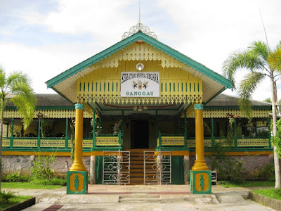
Sanggau is one of the second-level region in the province of West Kalimantan. Sanggau is one
The region is located in the middle and in the northern part of West Kalimantan province with an area of 12857.70 area
km² with a density of 29 inhabitants per km². Judging from geographical location Sanggau district lies between 1 ° 10 'latitude
North and 0 ° 35 'south latitude and between 109 ° 45', 111 ° 11 'east longitude. This area is the birthplace
Governor of West Kalimantan today, Cornelis MHKontrak 1756, Sultan Tamjidullah I of Banjarmasin with VOC-Dutch
Sanggau enroll in the sphere of influence of the Sultanate of Banjarmasin. According to the Statute van Nederlandisch Indie 1849,
This region included in the wester-afdeeling based BêsSuku nation in this area are:
Dayak Bidayuh in District Noyan, Sekayam, Kembayan, Sanggau, and Beduai, Jangkang
Dayak tribe in most of the District Sekayam Kerambay and Entikong
Mali Dayak tribe in the District Hall, Tayan Upstream, Downstream Tayan, Teraju, Parindu, and Sanggau
Dayak village in the district of Toba, Sanggau
Pandu Dayak tribe in most sub-district and Kapuas Parindu
Dayak tribe in most of the District Parindu Ribun, Tayan Hulu, Bonti, Kembayan, and Meliau
Dayak Iban in most areas of the border with Sarawak, Malaysia
Ethnic Chinese in most areas Sanggau
Malay tribes scattered throughout the region Sanggau [need citation needed]
In addition to the local tribes there are also other tribes who are newcomers, such as:
Javanese Ethnic
Sundanese
Batak Tribe
Minang tribe
Bugis
Madurese
Tribe Bima
Floresluit tribe van den Minister van Staat, Gouverneur-Generaal van Nederlandsch-Indie, on August 27, 1849,
Penjamur hill Bengkayang
This hill is not too high, only about 900 meters above sea level. Located in Bengkayang, which can be reached about 4
Hours overland from Pontianak, this hill is becoming a prima donna among nature lovers in the province. With tracks
which is not too difficult and access into an easily accessible, Penjamur Hill offers views of the sea of clouds and
sunrise is spectacular.


passed the equator. In the north of the city is, precisely Siantan, there Equator Monument which was built on the spot
passed the equator. In addition, the city of Pontianak also passed Kapuas River, the longest river in Indonesia and
Porcupine River. Kapuas River and Porcupine River which divides the city logo symbolized in Pontianak. This town
has an area of 107.82 kilometers persegi.Nama Pontianak derived from the Malay language is believed related
with a story that Syarif Abdurrahman often plagued by ghosts Kuntilanak when he along Kapuas River. According to
story, Syarif Abdurrahman forced to open fire cannon to repel ghosts while indicating where
cannon that fell, then that's where the region empire was founded. Cannonball went down near the river persimpang
Kapuas River and Porcupine, which is now known as Kampung BetingKota Pontianak is located on Line Tracks
Equator with an altitude ranging between 0.1 to 1.5 meters above sea level. City separated by the river
Kapuas Large, Small Kapuas River and Porcupine River. Thus Pontianak City is divided into three parts.
The structure of the city is a layer of peat former silt Kapuas River. Achieved a new layer of clay
at a depth of 2.4 meters above sea level. Pontianak city including tropical climate with high temperatures (28-32 ° C and
noon 30 ° C).
The average relative humidity in the area of the city of Pontianak maximum 99.58% and minimum 53% with an average irradiation
solar minimum 53% and maximum 73%.
The amount of rainfall in Pontianak ranging between 3000-4000 mm per year. Most rainfall (in wet) fall
in May and October, while the smallest precipitation (dry months) fell in July. The mean number of rainy days
average per month ranges from 15 days
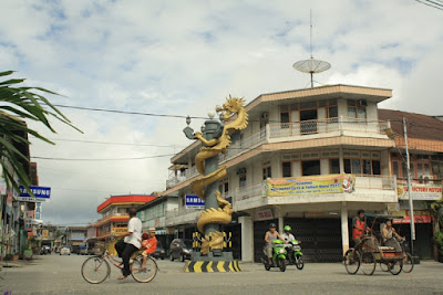
city singkawang

Singkawang or San Keuw Jong (Hanzi: ??? hanyu pinyin: Shankou that) is a city (municipality) in Kalimantan
Barat, Indonesia. It is located about 145 km north of the city of Pontianak, the provincial capital of West Kalimantan,
and surrounded by mountains Pasi, Poteng, and Sakok. The name comes from the Hakka Singkawang, San khew jong
referring to a town in the hills near the sea and estuari.Awalnya Singkawang is a village part of the territory
Sambas Sultanate, Singkawang village as a haven traders and gold miners from Monterado. Miners
and traders who mostly come from China, before they head resting on the first Monterado
Singkawang, while gold miners who had long Monterado often rested in Singkawang to take off
kepenatannya and Singkawang as well as the transit transportation of gold mining (gold dust). At that time, they
(The Chinese) call Singkawang San Keuw words Jong (Hakka), they assume that the geographical terms
Singkawang directly adjacent to the Natuna sea and there are mountains and rivers, where the water flows from
mountains through the river to the mouth of the sea. Seeing the development of Singkawang were assessed by their considerable
promises, so that between the miners switched professions there are farmers and traders in Singkawang
The miners eventually stayed and settled in Singkawang.
ketapan West Kalimantan

Ketapang city, a city located on the banks of the River Pawan. This district has an area of 31240.74 km² and
inhabited by 427 460 Life (2010) .At the reign of the Dutch East Indies, since 1936 Ketapang is
one area (section) which is part of the residency of West Kalimantan (Residente Western Afdeling van
Borneo) with the central government in London. Ketapang when it is divided into three Onder Afdeling,
that is:
Sukadana, based in Sukadana
Matan Downstream, based in Ketapang
Matan Hulu, based in Nanga Tayap
Onder Afdeling each headed by a district officer.
Each Onder Afdeling subdivided into Onder District, namely:
Sukadana consists of Onder District Sukadana, Simpang Simpang Downstream and Upstream
Downstream consists of Onder Matan Matan Hilir District and Kendawangan
Matan Upstream consists of Onder District Sandai, Nanga Tayap, tumbles Titi and Marau
Onder District each headed by an assistant district officer.
Ketapang section consists of three kingdoms, namely:
Matan kingdom which oversees Onder Afdeling Matan Matan Downstream and Upstream
Sukadana kingdom which oversees Onder District Sukadana
Kingdom who oversees Onder District Simpang Simpang Simpang Downstream and Upstream
Each kingdom led by a Panembahan. Until 1942, these regions led by:
Matan empire by Gusti Muhammad Saunan
Sukadana empire by Tengku Betung
Simpang empire by Gusti MesirMasa Dutch East Indies government ended with the arrival of Japanese troops in the year
1942. During the Japanese occupation, Ketapang still remain in the status Afdeling, only leaders
directly taken over by the Japanese.
Japanese occupation government that ended his rule in 1945 was replaced by the Government of the Netherlands Army
(NICA). At this time the existing form of government before they passed. Afdeling the Ketapang district status
enhanced with stard Blood 1948 No. 58 with the recognition of the existence of the autonomous government. At that time the district
Ketapng divided into three autonomous governments, namely Sukadana, Simpang and Matan, then all of the autonomous regions
there are combined into a federation.
Ketapang during the formation of the Republic of Indonesia Government is Based on Law No. 25 year
1956 which establishes the status of Ketapang District as part of the Autonomous Region of West Kalimantan Province, led by
a regent.
Sanggau

Sanggau is one of the second-level region in the province of West Kalimantan. Sanggau is one
The region is located in the middle and in the northern part of West Kalimantan province with an area of 12857.70 area
km² with a density of 29 inhabitants per km². Judging from geographical location Sanggau district lies between 1 ° 10 'latitude
North and 0 ° 35 'south latitude and between 109 ° 45', 111 ° 11 'east longitude. This area is the birthplace
Governor of West Kalimantan today, Cornelis MHKontrak 1756, Sultan Tamjidullah I of Banjarmasin with VOC-Dutch
Sanggau enroll in the sphere of influence of the Sultanate of Banjarmasin. According to the Statute van Nederlandisch Indie 1849,
This region included in the wester-afdeeling based BêsSuku nation in this area are:
Dayak Bidayuh in District Noyan, Sekayam, Kembayan, Sanggau, and Beduai, Jangkang
Dayak tribe in most of the District Sekayam Kerambay and Entikong
Mali Dayak tribe in the District Hall, Tayan Upstream, Downstream Tayan, Teraju, Parindu, and Sanggau
Dayak village in the district of Toba, Sanggau
Pandu Dayak tribe in most sub-district and Kapuas Parindu
Dayak tribe in most of the District Parindu Ribun, Tayan Hulu, Bonti, Kembayan, and Meliau
Dayak Iban in most areas of the border with Sarawak, Malaysia
Ethnic Chinese in most areas Sanggau
Malay tribes scattered throughout the region Sanggau [need citation needed]
In addition to the local tribes there are also other tribes who are newcomers, such as:
Javanese Ethnic
Sundanese
Batak Tribe
Minang tribe
Bugis
Madurese
Tribe Bima
Floresluit tribe van den Minister van Staat, Gouverneur-Generaal van Nederlandsch-Indie, on August 27, 1849,
Penjamur hill Bengkayang
This hill is not too high, only about 900 meters above sea level. Located in Bengkayang, which can be reached about 4
Hours overland from Pontianak, this hill is becoming a prima donna among nature lovers in the province. With tracks
which is not too difficult and access into an easily accessible, Penjamur Hill offers views of the sea of clouds and
sunrise is spectacular.


